






* 11:25 p.m. - Police determined people throwing food on cars at a College Street parking lot were determined to be members of a college lacrosse team goofing off. (So that's an alibi?)
* 2:23 p.m. - A West Street woman told police a man entered her home, took her phone and then replaced it with another phone. Police said there is no evidence such an incident occurred. (But is there any evidence that it didn't occur?)
* 8:56 a.m. - A North East Street resident reported an opossum got inside the chicken coop. (What are the laws on the books for this sort of thing? Should there be WANTED posters for animals?)
* 11:40 p.m. - Police kept the peace after a mother and daughter got into an argument over homework at Echo Village Apartments. (The police agreed to do the homework in exchange for coffee.)
* 1:27 a.m. - A woman seen streaking on Rolling Green Drive was not found by police. (Despite their arrival at the scene within two minutes of the call.)
* 2:48 a.m. - Two men running with ladders on North Pleasant Street near Phillips Street were gone when police got there.(An hour later two homes were robbed with the burglars inexplicably gaining access through second story windows.)
* 9:05 p.m. - Police determined that a Taylor Street woman's complaints about neighbors snowblowing snow onto her house and windows were not legitimate. Strong gusts of wind were determined to be responsible for the snow hitting her house.(Allegations that neighbors were shining bright lights into her house were determined to be caused by the sun.)


.jpg)






2 comments:
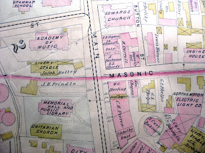
heyy! remember when the canal ran down Sate Street? did you know that is why India House is at an angle? and remember when a trolley ran through the meadows (!) to Springfield?!
oh, I love old maps.. That "Herlihy" on the corner in front of where St Mary's is now must've been the old livery stable that exploded in the night.. I forget why.. it's hidden somewhere in the Magical Microfiche.
Thanks for featuring Forbes Library collections on your blog! These maps and many more can be used Fridays and Saturdays 1-5 or by appointment. Call Forbes Library at 413-587-1014 for more information!
Post a Comment